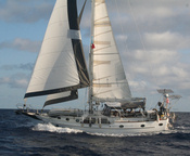


Since then, we have been having a great sail--15 knots on the beam--all afternoon. Just like when we used to go sailing for fun!! We averaged 7 knots for 3 hours!!. Now the moon is up, and the wind has eased to a nice 12 kts. We're going a little bit slower, but the motion is easier, too. I could do THIS for 2 weeks, easily.
Our friends on s/v Infini left about 2 hours ahead of us, and they are heading for a slightly different waypoint to go through the small islands and seamounts NW of Nuku Hiva, so they are about 10 miles NE of us right now, on a more northerly course. Another boat, Apple, left at the same time we did, and they are about 3-4 miles NW of us. We are all still in VHF contact, but by morning will likely be too far apart for VHF. We have an SSB schedule planned to chat every morning and evening, swap positions, and share weather information
"Only" 1,854 miles to go! At our historical average speed of 135 miles per day, we should be in Hilo Hawaii on Sep 30 or Oct 1. (but don't book your tickets yet!). The big unknown, speed-wise, is the ITCZ (formerly known as "The Doldrums"). This is an area of variable winds and squally weather. Historically boats could take weeks drifting around before they managed to break through an area like this. Fortunately, we have an engine in great shape and aren't afraid to use it. So the minute the wind dies off, we'll crank up Mr. Perkins and motor on through it.
We're not exactly sure what route we'll end up taking. Historically, people have headed north out of the Marquesas and set up to cross the ITCZ at around 140 west longitude, and then fall off for Hawaii. But we've been playing with the routing optimization software in the Maxsea charting program, and are going to follow its advice (until we decide not to). It takes in the GRIB files (weather predictions) and your boat's Polars (a table indicating what speed you can make in various wind conditions) and optimizes your route. Theoretically...
Sometimes Maxsea can come up with some pretty whacky results. But for now, I agree with what the optimization suggests. So we are headed 340 degrees (NNW) til tomorrow morning at least. This is almost directly on the rhumb line (the straight line course to Hawaii).
-----
At 9/17/2010 5:24 AM (utc) our position was 08°04.90'S 140°20.09'W
Labels: On Passage
or Posts by Topic links in the upper left!
For all our 2009 posts see Soggy Paws 2009
For posts prior to 2009 (all our Caribbean travels) see
Soggy Paws 2007 & 2008
Hawaii
Marquesas
Tuamotus
Gambier Islands
Pitcairn Island
Easter Island
Galapagos
Ecuador
On Passage
Fishing
Diving
Maintenance
Electronics
Galley
Cocos Island
Ecuador
Ecuador Inland
Chile Inland
Peru Inland
French Canal Boat
USA 2009
On Passage
Fishing
Diving
Maintenance
Electronics
Intracoastal Waterway
Florida Keys
Dry Tortugas
Belize
Belize Inland
Guatemala
Guatemala Inland
USA 2007
Honduras
Islands Honduras->Panama
Panama-Carib Side
Colombia
Colombia Inland
Panama Canal
Panama-Pacific Side
Costa Rica
USA 2008
On Passage
Fishing
Diving
Maintenance
Provisioning
The Blog Template is generated via PsycHo and is Licensed.