


I've been trying to catch up on posting pictures to our blog posts in March and early April. I am finished with the 'On Passage' stuff as far as Easter Island, and Easter Island itself. You can see the final result by clicking here Easter Island. Next is Pitcairn, and a couple of Gambiers posts I haven't gotten to yet. The internet here is R-E-A-L-L-Y slow, and I often get up at 5am to try to get a little better speed.
Our friends on Visions pulled out of the Gambiers almost a week ago, on a nice weather window. We just weren't quite ready. I lobbied strongly to pass on the window and take a few days to just relax. It is tough when my Dave and Bill from Visions of Johanna get together. It's go-go-go all the time!!
We have had a nice round of dinners and happy hours around the anchorage. Dave celebrated his birthday, and all of our group gathered for pizza and birthday cake. (Thanks, Sue, from Infini, for making the cake!!) We haven't remembered to take our camera often, but Dave caught this great picture of a few of the 'girls' during one happy hour in which we had a book swap.

Our friends on Aliisa finally arrived. They left Peru just about the same time we left the Galapagos, but it took them nearly a month longer to get here. They had better luck (or more fortitude) at Easter Island and managed to stay for 2 weeks.

Lauri and Anina are on the last leg of a 6 year circumnavigation. They hope to be in Cairns, Australia by September, where Lauri started from. You can see his adventures on his website at Aliisa.net.
The pizza parlor in town is only open Fri-Sat-Sun, so Saturday after Aliisa got in, we all went in for pizza. It was good--better than South American pizza, but we just about choked when we did the math and found they cost about $11 each for what was essentially a personal-sized pizza.
Now the weather has moved in, and we've got forecasts for 20-35 knot winds over the next 5 days as fronts and highs and lows roll past us.
We are actively looking for a weather window for the next jump--up to the Tuamotus. We have had nearly an unending succession of Lows roll past, bringing mostly NW-ly winds.
It is 450 miles NW to the Hao atoll. Though there are many islands and atolls between here and there, all are either islands with no real anchorage, or a closed atoll, with no pass big enough for a sailboat. We need a 5-day weather window, and looking at the GRIB files, it looks like the first possible departure date is May 4th or 5th.

That thing on the plate is 1/4 of a fresh pamplemousse (French Polynesian grapefruit).
Labels: Gambiers
There is no tourism industry here in Gambiers, so no one is really set up for tours. However, if you ask the right person, they will give you a short look around. Bill from Visions of Johanna set up this trip with Benoit at his pearl farm about a 20 minute walk out of town.

The first thing we learned is that the pearl farming work is usually done at a little building on stilts built over the water. We had thought those quaint little houses on the water were for living in, but it turns out to be a convenient way to deal with the pearl activities without stinking up the town. And easier for the coming and going of the oysters, etc. People commute to work from town everyday in launches with outboard motors.

They loaded all 9 of us up in the launch and took us out to their building. Benoit's son gave us a nice explanation of the process.


The first step in the pearl farming process is get oysters of the right size and development and implant both a seed pearl and a tiny chip of oyster shell into the gonads. The Japanese perfected this technique and some pearl farmers still use skilled Japanese workers to do this, though the French Polynesians are also learning how to do it.


Then they tie the oysters into racks and take them out in strings to their open water 'farm'. In the Gambiers, you can see many pearl farm bouys scattered around the open parts of the lagoon.

Periodically, they must retrieve the racks and clean the oysters, as clean oysters are happy oysters, and produce better pearls.

Some pearl-producing oysters are recycled, seeded again, after producing a good pearl. Others are saved for their shells. You can also eat the oyster muscle (similar to a scallop).

The hope was, at a pearl farm, that not only would we get some insight into pearl farming, but also be able to buy some pearls at a discount. Alas, it seems that all their production is controlled and they are not supposed to sell their pearls from the farm. There is a nice shop in town that has individual pearls and pearls in settings (rings, earrings, bracelets, and necklaces).
On our walk back from the pearl farm, someone invited us into their yard for free 'pampelmousse' (large sweet grapefruit grown on the island). We gathered all that we could carry!

Labels: Gambiers

I actually stopped and asked directions. One of the storekeepers in town that speaks English drew me a sketch map that helped us get on the right road. But his sketch was rough and turned out to not be quite accurate. He showed a path coming off the left side of a curve in the road, and that was accurate, it was WHICH curve that was the problem.
While Bill and Sue explored the path on the first curve with a path that we came to, I stood out on the side of the road and waited for someone to drive by. We had been passed by several pickups and motorcycles on the walk up, but of course when I WANTED a car to come, none did. Finally some guy came by on a motor scooter and I got him to stop. In my horrible (almost non-existent) French I asked where the path to Mt. Duff was, and we were able to communicate enough that I knew THAT path wasn't it. He indicated (sign language) that it was just ahead on the next curve.
There it was, properly marked with a sign that said Mt. Duff.
Once on the right path, it was actually a very pleasant walk thru a pine forest--a nice improved path for the tourists. We were joined by a skinny friendly dog of German Shepherd descent who was having a good time romping along with us.
We got to a Y in the path, with 2 signs in Polynesian, one pointing one way and one pointing the other. Neither said Mt. Duff! (this is a British name). If we had actually known when we started WHICH peak was Mt. Duff, it would have been easier. Our dog friend wanted to go to the right. We almost followed him. But Bill said the path to the left looked a little more worn. Hmmm... follow the dog who lives here or the cruiser who doesn't?? We followed Bill and went left.
After the Y in the path, we started scrambling up, still in pine forest. The slippery pine needles made the going tricky. In a few spots, there were lines between trees with knots in them, placed to help us go up and down the steep slope. At the very end, we got above the tree-line, and the path switched to wading through high grass. By this time, Bill was way ahead of us, out of sight, and Jo and Sue and I kept telling each other that there were no snakes in Paradise. (ha ha)
We finally made it to the top and climbed up on the rock outcropping. Wow, wow, WOW! What a view! We could see 50 miles in every direction. Out to the surrounding reef and well beyond. It was a beautiful clear day and we got some great shots of the clear water below.

-----
At 4/18/2010 4:04 PM (utc) our position was 23°09.61'S 135°02.27'W
Labels: Gambiers
We went on a dinghy expedition to the neighboring motu.


in 'safari mode'

Sherry found what we at first thought was a scallop, but which turns out to be a Black Pearl Oyster. They were found individually just laying around in the sand near a coral head. Like a scallop, we ate only the meaty muscle. It was good.

When we finally went ashore on the Puaumu motu, we found an abandoned house, and some pigs and chickens. They came running up when we came to the beach, looking for food. We found out the next day that someone comes from the 'mainland' every few days to feed them coconuts.

Labels: Gambiers
 Pascal from Steel Band is a 'hunter/gatherer' of the first kind. When we asked him where the best place was to get something to eat on the reef, he told us we probably won't find any lobster while snorkeling. And unfortunately, spearfishing is very risky here...ciguatera is very prevalent in Gambiers and those big fat grouper looking at us from under every coral head could be lethal.
Apparently, the way to find lobster here in the Pacific is to walk on the reef for them at night. The best time to do this, according to Pascal, is on a rising tide on a new moon (when it is darkest out and the buggers can't see you coming). The lobster are supposed to be coming up onto the reef top to feed around that time.
OK, well, we are not generally night people. It is safest to be back aboard when it gets to be dark, and we are usually not ready with dinner until 7:30 or 8pm. However, this sounded like a lark, and Visions was up for it too. We had an early dinner and withheld the drinks til after our adventure.
We gathered on the east end of the beach at Puaumu at 7pm, armed with sturdy tennis shoes, bright flashlights, gloves, and mesh bags. Dave also brought his Keys 'tickle stick' and net, which turned out to be useful. Pascal said we should be walking along the top of the reef (old dead reef) a couple of meters just inshore from the breakers. You just spot them with your flashlight and pick them up. How cool is that?
Gram from Visions and Pascal from Steel Band tromped off down the reef pretty quickly. Bill and Jo and Dave and I were much more tentative. Dave had to go back to the dinghy for something, and while he was gone, Jo found a smallish slipper lobster and Bill bagged him. When Dave came back, he already had 2 more.
We proceeded out to where Pascal said we should be--it was more difficult--deeper, rockier, and some wave action. After 10 minutes of nothing, we went back inshore a little where we'd found the other slipper lobster, and eventually found a total of 7 of them. It was slightly easier to bag them with the net and tickle stick, but it was not that hard to just grab them with a gloved hand.
Meanwhile, Pascal and Gram came back from way down the reef, with a stone crab and a good sized lobster.

Labels: Gambiers

THIS is what we traveled 5,000 miles for!!
We left Rikitea harbor yesterday morning to go out to the outer reef and hang out for a few days. Bill on Visions of Johanna had gotten some waypoints from a French boat (Steel Band aka Asterix) for going up into the 'unsurveyed' part of the atoll. And we could see a light wind period coming up, for a few days.
So about mid-day, us and Infini and Visions and Steel Band all headed out of the harbor, east to the edge of the reef, and north along the reef. We left first and ended up in the lead. It turned out to be a 'no-brainer' for us (we don't need no stinkin' waypoints!)--the water is really clear and easy to read. It is mostly very deep--60-80 feet. There are brown spots that are submerged coral heads at about 20 feet.
There is a solid reef all along the eastern side of the Gambiers atoll, with periodic 'motus'... little sand/coral islands. A few have palm trees... they look JUST like that Windows background with the sailboat and the island.
When we arrived at the island that Steel Band had put an anchor waypoint on, we worked our way into shallow water. It turned out to be a little harder than we anticipated to find a good anchor spot. There are too many very shallow coral heads. We picked the largest open area and dropped our anchor in what we hoped was the middle. The depth was only 10 feet, nice sand, so we didn't need a lot of scope. When Visions and Infini arrived, they didn't like the shallow coral-studded area and went back out into deeper water.
Ooops... we forgot to factor in the weather. All we had taken note of was wind SPEED when we looked at the forecast. It turned out that the reason the wind is dropping off is because of an approaching front. Last night the wind backed about 180 degrees. It left us sweating how close we were to a specific coral head. Just at dusk we had the foresight to swim out a second anchor to help keep us centered--we ended up hanging on that anchor all night long.
Fortunately, this 'front' was VERY mild. We had one rain shower and clocked 20 knots, but it didn't last long. Though the wind was most of the night coming from across the atoll, it was under 10 knots and so not a problem. Now, 24 hours after we arrived, it has back on around to the SE, and we are now hanging behind the reef again.
We are still getting used to this 'upside-down' weather. The cold fronts come from the south. And when they approach, the wind goes NE-N-NW-W and then blows cold air from the South after the front passes. Weird. And there is no Herb/Southbound II or Chris Parker here to explain the weather to us. Once we get a little further west and north, there are more nets and some weather gurus, but especially in this part of the Pacific, it's just us and the GRIB files. We are finally in the French Polynesia weather area. But the weather we can get from Saildocs is sparse, for only 'today and tomorrow', and in French. Here's yesterday's forecast for our area:
GAMBIER
SECTEUR EST 11/16KT MOLLISSANT 07/10KT A MI-ECHEANCE PUIS REVENANT AU SECTEUR SUD-OUEST EN FIN DE PERIODE, RAFALES 25/30KT SOUS GRAINS, MER AGITEE DEVENANT PEU AGITEE, AVERSES EPARSES OU GRAINS ISOLES.
Yep.
Anyway, where we are is just GORGEOUS. Sand beaches, palm trees, aquamarine water, beautiful coral, warm water, sunshine. It doesn't get any better than this.
-----
At 4/10/2010 5:48 AM (utc) our position was 23°01.09'S 134°55.21'W
----------
Labels: Gambiers

We are in Rikitea Harbor, on Mangareva Island, in the Gambiers group of islands, in French Polynesia. We are glad to be back in the tropics. (This image is from a postcard)
We have a little bit of internet, but it is VERY VERY slow. We are asking all our friends to please please please DO NOT send us any attachments, or those cutsie email forwards.
We love hearing the news from back home and very much welcome emails, but we just can't take any big emails. Someone today sent me a 9MB email that would have taken us an hour to download (and we are paying by the minute for all our internet these days).

We got checked in with the Gendarmerie. It took us 15 minutes and a 70-cent stamp (to mail our paperwork to Papeete).

A supply ship came in yesterday, so we spent most of yesterday and part of today getting everyone topped off with diesel. We bought 6 55-gallon drums of fuel for 3 boats, and then pooled all our jugs and dinghies to ferry the jugs back and forth. What a process! And it 'only' cost $5.50/gallon. Our share was almost $500!! We are very thankful in these capers, for our ECSA siphon hose!!! Hopefully it is the last diesel we'll have to buy before we leave the Marquesas for Hawaii in September.
The wind is supposed to drop off starting this afternoon, so we are planning to go out somewhere to the edge of the reef behind a 'motu' (small island on the edge of the reef) and hang out and go snorkeling, etc, for a few days.
Labels: Gambiers
We anchored in the lee of Akamaru island for about an hour, to get things sorted out, have breakfast, and wait for Infini. While we were there, a guy came up in a skiff, introduced himself, welcomed us to Mangareva, and presented us with a few huge 'pampelmouse'. These are the Polynesia version of grapefruit. Very tasty! Anchorage position: 23-11.289 S 134-55.466 W.
An hour later, having navigated across the lagoon using the very accurate CM93 charts in Maxsea, we dropped anchor in 45 feet in Rikitea harbor. Anchorage position: 23°06.91'S 134°58.05'W
We will clean up, have lunch, launch the dinghy, and go ashore this afternoon to the Gendarmeria to present our paperwork.
We are now on French Polynesia time, which is -9 from UTC, and -5 from EDT.
----------
radio email processed by SailMail
for information see: http://www.sailmail.com
Labels: Gambiers, On Passage

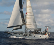
The wind has remained steady all day at 12-15 kts from 080 degrees. We have the same sailplan as yesterday (haven't touched a thing in 24 hours)... slightly reefed main, vanged to port, genoa poled to starboard, and the staysail down the middle. Sweet!
Another nice sunny day in the tradewinds.
Tomorrow: French Polynesia at last!
-----
At 4/6/2010 2:53 AM (utc) our position was 23°41.33'S 133°48.37'W
Labels: On Passage
But this morning, as forecast, the wind came up to about 10 knots. We've been having a nice sail all day with a wing-on-wing configuration. We have the genoa poled out to windward, the main vanged to leeward, and the staysail sheeted tight in the middle. This is a great downwind configuration--very balanced, so it is easy on the autopilot or windvane. And the staysail provides a little roll control.
The wind has built slowly during the day, so now we have more like 12 knots. We are making about 5.5 knots directly for Mangareva.
We have about 195 miles to go. ETA at the SE pass at Mangareva is early Tuesday morning. We are REALLY REALLY looking forward to a nice calm anchorage. We have been underway or in dicey anchorages since March 2.
-----
At 4/5/2010 2:43 AM (utc) our position was 24°18.03'S 131°35.31'W
----------
radio email processed by SailMail
for information see: http://www.sailmail.com
Labels: On Passage
It started early with a call from Infini on VHF as they were (finally) approaching the island. We guided them in to a good anchoring spot.
At 9:30, Brenda Christian and 'Radio Dave' Brown were out in the skiff to collect us and Infini. We went with them to Brenda's house, and enjoyed more warm bread and Pitcairn honey at Brenda and Mike's, while Infini filled out their paperwork.
We organized lunch at Betty Christian's Cafe, with Dave's help, and then set off with Brenda and Mike on 2 quads for the quick tour of the island. We had already seen a couple of the sights yesterday with Bruce, but were happy to go again. Brenda encouraged us to make the hike down to 'Down Rope' and see the Polynesian glphys carved in the rock face. It was a near vertical scramble down and back up, but worth it for the look at the glyphs and a chance to beachcomb a little. We visited Ship Landing Point and St. Paul's again, this time with Infini. More pictures!! Sue and I actually followed Brenda way out on the 'nose' of Ship Landing Point (see photo when posted, which Bruce took from his house below). We also went to 'Highest Point', which has the famous signpost showing how far it is to everywhere important. More pictures!!
Another great lunch at Betty's Cafe. Dave loved the huge smorgasbord. I loved sharing lunch with such a variety of people, including Tom and Betty Christian, both direct descendents of the mutineers, and their daughter. There were also a couple of the passengers from the 50' sailboat Southern Cross, who makes passenger trips to Pitcairn from Mangareva.
After lunch, Infini went to see the museum, post office, and town area, and Dr. Bruce came to collect us again and we set off for the other end of the island. We stopped at John Adams grave (the only marked grave for a male member of the mutineers). John Adams was the last surviving male mutineer, and converted the rest of the islanders to Christianity, after learning how to read from the Bible. The whole 'on Pitcairn' part of the mutiny is a fascinating story. If you're interested in reading the whole saga, look for a copy of the Bounty Trilogy. It details the pre-mutiny, the mutiny, life on the island, and life on Captain Bligh's longboat after being set adrift from the Bounty.
Then Bruce took us out toward 'Tedside' and (???)'s Ridge. The ridge gave us a great lookout over the town and the boats at anchor. The attractions of Tedside are 'Mrs T', a Galapagos tortoise who roams there--originally brought by Irving Johnson on one of his circumnavigations, and a blowhole. The blowhole is caused by big waves forcing themselves thru lava tubes.
We had a nice cup of tea with Bruce and his wife, and then Bruce ran us back to the landing area.
We had asked if there were fruits and veggies available on the island. We ended up with literally 20 lbs of bananas, some ripe and some not, and a great deal of fresh garden veggies including cucumbers, sweet potatoes, passion fruit, carrots, corn, a pumpkin etc. Several people had donated to our pile on the quayside, but again, special thanks to Carol, Brenda, 'Radio Dave' the banana man, and Bruce & his wife. Anyone want a banana??
We had been on the fence all day about whether to leave in the evening or not. Each islander we met asked how long we were staying, and we'd waffle every time. Each of the cruisers were facing the same question and all were waffling as well. The islanders were pooh-poohing the forecast we had of big swell coming.
But when we got back to the landing area and saw the anchorage, our minds were made up "Let's get the heck out of here.". Brenda took us back to the boats, thru the surf, and we had our anchor up within an hour. Infini at first had said they were staying, but after an hour aboard at the anchorage, they also decided to leave. The only boat left at sunset was Zephyrus, who were firmly committed to staying, no matter what.
We loved Pitcairn. We loved the island, and thoroughly enjoyed the people. Would have loved to have stayed longer. Would love to come back some time.
But we are now 15 hours into a 55 hour passage to Mangareva, Gambiers. This is the SE tip of 'French Polynesia'. Since we did so much motoring to get to Pitcairn, we turned the engine off as soon as we cleared Pitcairn, and drifted along at 2 knots most of the night. But now the wind is a good 10-12 knots and we are making good time toward Mangareva. ETA Tuesday morning sometime.
-----
At 4/4/2010 6:10 PM (utc) our position was 24°30.19'S 130°54.85'W
----------
radio email processed by SailMail
for information see: http://www.sailmail.com
Labels: On Passage, Pitcairn Island
We had called ahead on VHF channel 16 and made contact with Dave Brown, whom we'd been talking with on the Ham Radio for a couple of weeks. And we also talked to Brenda, who is in charge of handling the 'formalities' at Pitcairn.
Soon after we had the anchor down, Brenda and Geoff, the local policeman, were alongside in their 'canoe'. This turned out to be a good sized skiff with an outboard motor on it. We were ready for them, and quickly jumped aboard. Even in this benign weather period, there is a pretty good roll in the anchorage, so the skiffs don't tarry alongside very long.
They brought us in to the landing area, through a swell that could become a surf zone when the waves get higher. There is a quayside, and then they pull the boats up a long ramp to get them above the tidal zone. (pictures to follow later).
Ashore, we were met by the young guy responsible for the Agricultural inspection. We had to fill out a short questionaire, and he inspected the apples we brought ashore, but otherwise this was pretty painless.
Then Geoff and Brenda loaded us and the crew from Zephyrus, who had arrived the night before, onto their 'quads' and whisked us up to Brenda's house to complete the paperwork. The main mode of transportation on Pitcairn is a 'quad'--the 4-wheeled ATV. They are perfect for the dirt roads and hill country at Pitcairn. Everyone has a platform on the back that will accommodate 2 passengers (hanging on for dear life).
Brenda and Mike Christian's house is up on a hill overlooking Bounty Bay. They have a killer view, and today was a beautiful sunny day. The sea below was crystal clear and very tranquil. While Brenda fed us hot bread fresh out of her oven, and lathered with Pitcairn honey, we filled out paperwork, got our passports stamped, and got a briefing on all the things to do on the island. She made arrangements for us to go to Betty's Cafe for lunch (you must call ahead).
The islanders were all abuzz with the fact that there were 5 sailboats at one time in the bay. Someone said they thought that was a record! (in addition to us and Visions of Johanna, we also had the British boat Zephyrus and the Canadians on Pursuit IV, and a charter sailboat out from Mangareva named Southern Cross.
While down on the wharf, Bill from Visions introduced us to Bruce, who is the doctor on the island. Bruce is an Australian who has contracted for a year to be the resident doctor. Bruce has only been at Pitcairn for a month, but is already in love with the island. The islanders provide the visiting doctor with a house and 2 quads, and a nice clinic from which to operate.
Bruce had kindly offered to show us a few places on his quad after lunch. So we climbed onto the back and roared off up into the hills. We stopped at Ship Lookout and took pictures of the sailboats in Bounty Bay. We stopped at 'Down Rope', which, after a steep hike down the hillside, it's possible to see some ancient Polynesian rock carvings. We didn't actually hike down, but we did take a picture down the hill. And then we went to St. Paul's Pool, where we hiked down to the pool and watched the southerly swell crash and spill over into the pool.
Everywhere we went, there was lush vegetation and absolutely stunning views of the island and the ocean. It felt like you could see 100 miles in any direction.
After our tour, Bruce dropped us off at the town square about 4:30 pm. Brenda had arranged for the Post Office and the Museum to be open for an hour or so, just for us. We bought a fantastic array of Pitcairn stamps at the Post Office (about $60 worth, a set for us and one for Infini--just in case they are unable to get to the Post Office). And then we went into the little museum. It was small, but full of fascinating bits of Pitcairn history.
We lucked out in being at Pitcairn when the islanders were having their about-every-3-weeks Friday night social get-together. It's a big potluck in the town square, and just about everyone on the island attends. For this occasion, a traveling Christian musician from India named Benny Prasad was going to perform in the church after supper. We had a really nice typical potluck supper, and got to just sit and chat with many of the islanders.
Benny's story is that God told him that he was going to send him to every sovereign country in the world to play music and spread the word of God. He is only 15 countries short of visiting every country in the world. It's an amazing story and he's a very interesting young man. You can read more about Benny at www.bennyprasad.com
Somewhere between the potluck and Benny's performance, we went with Dave (VP6DB) up to his house and his ham shack, and did a quick check-in with the Pacific Seafarer's Net, to confirm our 'safe arrival' at Pitcairn.
We really enjoyed listening to Benny on his unique 'bongo guitar' in the church.--Nice acoustical guitar music, with a few of Benny's stories about his travels interspersed. Then we went with Dave and the other cruisers down to Christian's Cafe, a nice cafe/bar, where we had a couple of beers. By this time, Dave and I were absolutely dead on our feet, so we begged off and got Dave and Brenda to ferry us back to the boat.
What a full day! What an amazing day! I think we've met fully half of the islanders. What a friendly and interesting bunch of people. We could easily spend a couple of weeks here, if there was a safe anchorage to do so. I am so sad that weather will force us away before we've really had time to enjoy the island fully.
Tomorrow, we expect Infini to arrive early in the morning--we talked to them tonight and they were only 50 miles out. We hope to get a full day ashore tomorrow and do some more exploring. But the swell is expected to pick up starting tomorrow afternoon--so we're not sure how long after that we'll be able to stay.
-----
At 4/3/2010 6:35 AM (utc) our position was 25°03.98'S 130°05.69'W
----------
radio email processed by SailMail
for information see: http://www.sailmail.com
Labels: Pitcairn Island
-----
At 4/2/2010 6:03 PM (utc) our position was 25°03.99'S 130°05.69'W
----------
radio email processed by SailMail
for information see: http://www.sailmail.com
Labels: Pitcairn Island
We've been motoring all night in calm conditions. It is hard to believe that this is the same ocean that just 2 days ago was kicking the stuffing out of us. The surface of the ocean is glassy (though we can still see the big swell that never goes away).
Just after sunset, the stars were out last night by the billions, and then the full moon lit the way westward for us most of the night.
We've been communicating with a Ham Radio operator on the island named David, VP6DB, through the Pacific Seafarer's Net, and he was the first one to answer our VHF call this morning. We plan to be at anchor in Bounty Bay in 2 hours!
Infini finally started their motor when the wind dropped to zip. They are about 100 miles behind us, and expect to be in to Bounty Bay tomorrow morning.
To read some other info about Pitcairn...
Here is s/v Nine of Cups account of their visit last year:
http://www.nineofcups.com/pitcairn.htm.
And the Pitcairner's own tourism website:
http://www.visitpitcairn.pn
-----
At 4/2/2010 3:45 PM (utc) our position was 25°03.78'S 129°54.02'W
----------
radio email processed by SailMail
for information see: http://www.sailmail.com
Labels: Pitcairn Island
Our friends on Infini have declared that they are not motoring in. They are still sailing. I envy them the tranquil sailing, but only time will tell who gets to actually SEE Pitcairn. Mike has been talking about Pitcairn ever since we started out on this trip. He just refuses to motor. We expect them to arrive just about the same time a 14-16 foot swell arrives. They are talking about heaving-to for a few days to wait out the bad swells at Pitcairn. Good for them.
For me, I'm ready for THIS adventure to be over. We're counting the days til we're in the Gambiers, in a nice reef-enclosed anchorage. And it looks like we're arriving at Pitcairn in a nice lull, so we'll actually be able to go ashore.
Today was a picture perfect day, but the wind is still decreasing. And to make matters worse, it has gone to the NW, so it is now too close to the nose to be sailing. We finally pulled in the genoa an hour ago. We're hardly getting anything but stability out of the mainsail.
Dave just went to take a picture of the calmness. It isn't yet 'flat dead calm'. There are ripples on the water, and still the big swell. But it is long period and isn't bothering us at all. I'm having fun cooking a real dinner tonight! (Shrimp Stir Fry... yum!)
We're in the process of making 80 gallons of water. I did a little laundry--about 10 days worth of underwear--in the sink. We have enough T-shirts to last a lifetime, so underwear is the only thing we get a little stressed about. The last time we did laundry was about Feb 28! We wanted to get our laundry done at Easter Island, but never got the chance before weather chased us out.
-----
At 4/2/2010 1:32 AM (utc) our position was 25°05.39'S 128°23.26'W
----------
radio email processed by SailMail
for information see: http://www.sailmail.com
Labels: On Passage
Dave and I "discussed" all afternoon yesterday whether and when to turn the engine on. Dave's argument was that we'd come almost 3,000 miles to see Pitcairn, and we had a good weather window to do so coming up, and we should motor like hell to get there and make the most of the calm weather. My argument was that this was the best sailing weather we'd had in 4 weeks, and we should enjoy it. His logic prevailed over mine, and we cranked the engine right after dinner last night.
We motorsailed all night in 8-10 knots of relative wind (part of it being made by the forward speed of our engine), making 6 knots straight toward Pitcairn. We are now pretty certain we will arrive between 8 and 9am local time tomorrow (Fri). (ONLY 24 more hours of 'rrrrrrrrrr' of the engine!).
We both got caught up on our sleep last night, both off watch and on watch. The conditions were tranquilo (et tranquil en francais), we haven't seen another vessel in weeks, and we were pretty fatigued from the ordeal of the last week. Each of us slept through at least one 'wake up' alarm while on watch!
This morning, I fixed a nice 'Sunday Breakfast'... scrambled eggs, grits, and toast, and we put up the cockpit table and had a nice civilized breakfast, complete with orange juice (boxed).
With engine on, we've got lots of battery power, so we will likely catch up on computing tasks and charge all the rechargeable batteries on the boat. We might even watch a video of 'Mutiny on the Bounty' this evening.
History Lesson: Pitcairn Island is where the Bounty mutineers ended up after they cast Captain Bligh adrift in one of the longboats. They chose Pitcairn because it was remote. They were (rightly) afraid of being discovered, and hanged for mutiny. Several missions to locate the mutineers were dispatched by the British Admiralty after news of the mutiny reached England.
The descendents of Fletcher Christian and the other mutineers, and the Polynesian families that accompanied them to the island, are still living on Pitcairn. It is now a British protectorate.
-----
At 4/1/2010 4:20 PM (utc) our position was 24°59.43'S 127°29.04'W
----------
radio email processed by SailMail
for information see: http://www.sailmail.com
Labels: On Passage
or Posts by Topic links in the upper left!
For all our 2009 posts see Soggy Paws 2009
For posts prior to 2009 (all our Caribbean travels) see
Soggy Paws 2007 & 2008
Hawaii
Marquesas
Tuamotus
Gambier Islands
Pitcairn Island
Easter Island
Galapagos
Ecuador
On Passage
Fishing
Diving
Maintenance
Electronics
Galley
Cocos Island
Ecuador
Ecuador Inland
Chile Inland
Peru Inland
French Canal Boat
USA 2009
On Passage
Fishing
Diving
Maintenance
Electronics
Intracoastal Waterway
Florida Keys
Dry Tortugas
Belize
Belize Inland
Guatemala
Guatemala Inland
USA 2007
Honduras
Islands Honduras->Panama
Panama-Carib Side
Colombia
Colombia Inland
Panama Canal
Panama-Pacific Side
Costa Rica
USA 2008
On Passage
Fishing
Diving
Maintenance
Provisioning
The Blog Template is generated via PsycHo and is Licensed.