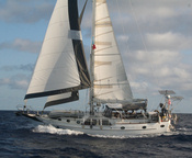


Our main focus while here in Anaho Bay has been getting ready for the two-week, 2100-mile sail to Hawaii. In between hikes and snorkeling expeditions, both us and our friends on Infini have been working on boat maintenance issues--bottom scrubbing, rigging checks, leak fixing, etc etc.
I have also pre-cooked about a week's worth of meals, so all I'll have to do is pull something out of the freezer and heat it up.
Plus I've spent a lot of time over the last month collecting weather information about the trip. Mainly just watching weather patterns so we know what to expect. It should be a pretty decent trip. We are starting on a good weather window--wind today should be just aft of the beam at 15 knots. We'll sail N-NNW for the first week or so, until we get across the ITCZ (motoring if the wind gets too light), and then fall off in the northeast trades for our destination of Hilo Hawaii.
Though Sailmail gives us great access to many bits of weather information, we have enlisted our friend Winnie, a professional meteorologist based in Florida, to keep an eye on the 'big picture' for us. We are also getting advice from a Danish guy named Karsten who has been doing Pacific weather for cruisers out of Panama for awhile.
We will be in company with 2 other boats--Infini and another boat here headed for Hawaii called Apple. Apple is a Jeanneau 44, and is likely to go faster than us--though he swears he'll try to slow down and stick with us.
We expect to make landfall in Hilo, Hawaii sometime the first week in October. The direct-line course from here is about 2100 miles, but because of the way the winds go between here and there, we may dog-leg east a little bit from a direct course.
In the last couple of months, we have finally gotten around to doing some of the less important tasks on our list--things like hooking our GPS to our EPIRB, so our emergency beacon will broadcast an accurate position if we sink. Though somewhat important, it never made it high enough on the list before our long trip to Easter Island. So we are more prepared for this trip than we ever have been. And the crew is ready...with over 6,000 miles under our belt already this year, we feel pretty seasoned!!
We plan to do a blog post and update our position at least daily. The easiest and quickest way to see where we currently are is via the Findu link:
http://www.findu.com/cgi-bin/find.cgi?call=KN4TH
But there are several other ways--check our Positions page on the website: svsoggypaws.com/positions.htm
Labels: Marquesas, On Passage
We arrived in Anaho Bay, on the NE corner of Nuku Hiva, the northeastern-most of the inhabited islands in French Polynesia, about a week ago. It is the best anchorage we've been in so far in all of the Marquesas (except maybe Hanamoenoe in Tahuata).
This time of year, there is a large SE swell that makes all the anchorages on the south coast of Nuku Hiva really uncomfortable. And Taiohae, the main harbor, is particularly crappy, both because of the large swell and because of the 'williwaws' (wind gusts) that come from every direction. Daniel's Bay is better, but a little cramped, and still a little rolly. Anaho is flat calm and beautiful, and the wind blows from a constant direction at a reasonable speed.
It is a large bay with a series of pretty beaches interspersed with coconut-dotted rocky points. As everywhere on Nuku Hiva, there are signs here of a large population in the past. There are walls and tumbled-down rock structures buried all over in the foliage--all that remain of the 10's of thousands of Polynesians who lived here when the Europeans first made landfall.
There are only a few families living here now, but they keep the grounds pretty well-tended. There are the usual large coconut plantation areas, which they tend by piling all the fronds and husks into piles and burning. The coconuts get piled up and left to dry, then they are opened, and the meat extracted for 'copra'. This is eventually shipped to Tahiti and becomes coconut oil and other byproducts.
They also have the typical Marquesan gardens filled with fruit-bearing plants. We have been able to trade a few things for all the fruit we needed--especially bananas, mangoes, and limes. We got rid of the last of our 22 shells and a pack of old cigarettes for a huge stalk of bananas and some mangoes.
We were also able to trade for some pearls. There is a French boat anchored here who has spent 18 months in French Polynesia. He's a diver and spent a season helping a pearl farmer in the Tuamotus, and he was paid in pearls. So he came to us offering to trade some pearls for any leftover wine and other food we could spare. So we had a nice happy hour session with us and Infini and Florent, trading for pearls and going over all his favorite dive spots in the Tuamotus. We all came away from the trading session happy--we got a few 'quality' pearls, a few 'B' grade pearls, and a handfull of less than perfect pearls, but ones which family and friends will enjoy having as a small memento of our travels (we hope).
We have done 2 of the possible hikes in this beautiful setting. There is a lot more hiking to be done, but we're ready to head north soon. One beautiful afternoon, we hiked east over the low peninsula to the windward beach. We were warned that the beach would be buggy with no-no's (tiny biting flies much worse than mosquitos), so we went in socks and long pants and long-sleeved shirt. But it was pretty windy and I think that much coverup was overkill on that day--it was really hot hiking in all that clothing on a sunny day out of the wind!! We found a pretty beach, some semi-wild horses, some possible remains of an old habitation and not much else. We never did find the little farm back in the trees where friends had gotten fruit.
We also hiked over to the town of Hatieu, to the west. This was a little harder hike--up over a pretty high hill and down into the next bay. But it was mostly wooded and we picked an overcast day, so it wasn't too hot. The whole trail was lined with old mango trees. But some of the mangoes we collected on the ground--ven ripe ones--tasted very very tart--almost like a lemon--certainly not like any mango we ever tasted. In Hatieu, we visited the grocery store where an ice cold Tahitian beer was waiting for us. And also, of course, onions, cucumbers, potatoes, chips, and frozen baguettes. We ate lunch at Chez Yvonne on the water (we had called ahead on the cell phone for reservations, but may not be necessary). It was a yummy big lunch--most of their meals were in the $2000 CFP range (a little over $20). Between the 5 of us we had curried goat, curried shrimp, poisson cru, and goat in coconut milk. It was all good, and large portions. Even Dave was stuffed when we finished. Hatieu is a pretty little town anchored by a fairly large, fairly new catholic church. The caretaker of the church let us in for a quick look--it is only 5 years old, so pretty modern in design--'airy' is the best word to describe it. Probably built on the ancient foundations of a Marquesan marae (sp?) platform.
As everywhere in French Polynesia, we could easily spend 2-3 times the time we have spent here, and not be bored. Too bad the French insist on limiting our time here!! A 2 year cruise in just French Polynesia would not be too long, in my opinion. We have only touched on half of what's here, in the 6 months we've been here.
-----
At 9/15/2010 2:35 AM (utc) our position was 08°49.35'S 140°03.89'W
Labels: Marquesas
From the main town of Taiohae, on the south coast, to Anaho Bay, on the NE corner, it is clearly best to go 'eastabout' to get to Anaho Bay... shorter and less windward work. But leaving from Daniel's Bay, on the SW corner, the choice was not so clear. It was slightly shorter to go eastabout, but with an ESE wind, it should be much calmer going westabout.
After flip-flopping several times, we finally decided to go around the west coast. It would give us smoother water (for awhile), a chance to see part of the coast that most people don't go, and a chance to make water with our engine-driven watermaker. (It's a little dicey making water in the anchorages due to the amount of particulate in the water).
We also opted to break the trip into two parts, stopping overnight at what's known as the 'airport anchorage'--Baie Haahopu at the NW corner of Nuku Hiva.
Exploring the west coast--motorsailing slowly north and ducking into every little bay we saw to check it out--was fun. We hadn't done that type of gunkholing in awhile. Though the guidebooks only mention one or two anchorages on the west coast, we found a total of 7 bays 'possible', with reasonable protection and anchorable depths. As follows, N to S:
- Baie Marquisienne
- Anse Haatapuna
- Anse Tataia
- Anse Tapueahu
- Anse Haatuatua
- the unnamed bay just N of Pt Matatekouehi
- Baie Haahopu
A couple of these had signs of habitation--one house and a small skiff. But most were completely deserted. Some had rocky beaches, but as we got further north, more of them had sand beaches. Baie Haahopu had a pretty sand beach, but an ugly concrete dock and a building (uninhabited).
Once we got around Cap Motumano, the waves started settling down, and after rounding Pt Matateteiko, it was flat calm for the rest of the way.
The west coast of Nuku Hiva is arid and dry, so with little runoff, the diving ought to be clearer. We could easily see the bottom in 25' in Haahopu. We found another cruising boat there when we arrived, and we anchored just inside of him in at 08-49.5S / 140-14.94W in sand. There are some coral heads around, but lots of sand, so try to pick a spot in sand. From here it is possible to dinghy a crewmember into a cement dock and (hopefully) hitch a ride to the airport (but we didn't do this, so don't know the logistics). Most people opt to taxi over from Taiohae.
The winds were kind of weird on the west coast in the afternoon--we had a good 12-15 knots blowing from the WEST (against the trades). Obviously a 'sea breeze'. It died down at night and switch to the east.
The next morning we left early to head east along the north coast of Nuku Hiva. With the wind south of east, we had hoped to find some lee by staying close in along the coast. We did, but it wasn't as much lee as we had hoped. It was really wild going around the NW corner--big steep waves, lots of wind, and a couple of knots of current against us. But that didn't last long (the current died and the waves lengthened). We short tacked along the coast, staying in as close as we dared to get a little shelter behind small headlands.
It took us about 4 hours to go the 12 miles to Anaho Bay, but we did duck in and explore 2 bays on the way. Baie Hakaehu, where the town of Pua is, and Baie Hatiheu, where the town of Hatiheu is, are both possible anchorages, but not nearly as nice as Anaho. There are other possible anchorages, I think, along the N coast that we didn't explore--we just got tired of bashing to windward and wanted to get it over with.
When we arrived in Anaho Bay, we found 3 other boats. Our friends on Infini were here, and a French boat and a Belgian boat. These other 2 boats, being EU citizens, have the luxury of just hanging out in French Poly--the French boat had been all over all of French Polynesia, diving, for the last 18 months. We have a nice anchorage here in 35' sand in a beautiful bay.
-----
At 9/15/2010 2:35 AM (utc) our position was 08°49.35'S 140°03.89'W
Labels: Marquesas
We actually made 2 visits to Daniel's Bay, staying a total of a week there. The proper name for Daniel's Bay is Anse Hakatea, but among cruisers, it is known as Daniel's Bay. For many many years, the bay was home to a man named Daniel who was very welcoming to cruisers. He even went to the trouble of piping fresh water out to a bouy in the anchorage, so cruisers could easily take on fresh water from his water supply.
Unfortunately, the popular series 'Survivor' came to Hakatea one day and persuaded a very old Daniel to move to town, so they could use his isolated bay to film a Survivor series. Daniel passed away soon after, and his bay is now uninhabited.
However, there is still a small friendly village in the adjacent bay, within easy walking or dinghy distance. And there is still the '3rd highest waterfall in the world', only a 2 hour hike away. And it is still a better anchorage than the rolly gusty anchorage at the main town of Taiohae.
We made our first hike to the waterfall with our friends on Infini, who had already visited Daniel's Bay before. They knew the way, and so we had an easy hike on a nice sunny (dry) day.
The hike starts in the tiny village of Hakaui--really just 4 or 5 houses, surrounded by carefully tended gardens. There is a tiny church, no post office, no central electricity, and no cell phone signal. We understand that most people nowadays don't live full time in this village. Their main house is in Taiohae, and they visit their home in Hakaui on weekends--leaving a caretaker or one part of the family to stay in the house and tend the gardens.
The 'gardens' are a combination of flowers, ornamental shrubbery, and fruits and vegetables... including bananas, mangos, papaya, citrus, guava, manioc, breadfruit.
There is a fresh water stream that runs through the village and out into the bay. At high tide, it's possible to get a small outboard over the 'bar' and into the stream. It's a bit of a challenge--the bay is swelly and usually has some waves breaking on the rocky beach and across the river mouth. So you have to time the passage through the waves, and hope you don't miss the deep part of the small stream... grounding at the entrance is a good way to get swamped by the waves, which we did once. At low tide, it's still possible to get an inflatable dinghy with a light outboard in--you just have to be prepared to have everyone hop out of the dinghy and drag it in through what's left of the stream to the deeper water.
The alternative to surfing in over the bar is to haul your dinghy up very high on the beach in Daniel's Bay, and walk along the beach to the left to the start of the path that goes over into the village in the next bay.
The hike to the waterfall follows an old 'road', up through the valley along the stream. If you pay attention as you are walking, you can see that the path was once improved--in the low spots, there is a 2-3' high wall of fitted stones on either side, with earth filled in between. This keeps the path dry even when it rains. The path is still lined with ornamental shrubs in many places. On either side of the path, set back into the woods and nearly covered with jungle, you can see old massive stone platforms, usually surrounded by fruit trees...the only thing left from what was once a flourishing community of Marquesans in a spectactular setting.
The problem with the waterfall is that it is set in a 'fold' in the mountain, and when you are at the base of the falls, you cannot see the top of the falls at all... only the last 100 feet of the falls are visible. But, halfway there, at a wide spot on the path, there is a great view off to the left, over the jungle, over the stream, to the waterfall. (See picture, to be posted sometime when we have internet). This is also a spot where there is another massive stone platform that probably had a good view of the falls and most of the valley.
At the falls, there are some giant rocks (15 feet high) and a small pool. We swam across the pool and between the rocks to actually sit under the base of the falls. When we were there, the water was running pretty good, the falls were too strong to stand under, and there was a really wet and cold downdraft in the little cave area where the water comes down. We didn't stay long there.
We also found some fresh water eels and small shrimp in the pool. One of these eels was quite big--similar in size to a big green moray eel--and lurked just off the 'beach' waiting for handouts. We had fun feeding the eels and shrimp bits of our lunch.
After the hike, Mike and Sue took us to Ma'i and Maria's house, back in the village, facing the bay, on the far left (west) side of the rocky beach. Maria's family has been prominent in the village for generations, and she and her husband and young son are now the latest 'caretakers' of this prime family property on the beach. In addition to her native Marquesan, Maria speaks fluent French and pretty good English. Since Daniel's demise, and because she speaks both French and English well, Maria has been host to many cruisers. We traded some 22 shells and shotgun shells for a nice lunch of traditional Marquesan fare, including 'poisson cru', goat in coconut milk, and breadfruit prepared 2 ways. (They use the ammunition to go up into the hills and hunt the wild goat and wild pigs that roam the island).
Over lunch, Ma'i offered to take us goat hunting and pig hunting, if we were interested. So we set up and expedition for the next day, to scramble up the rocky, arid face of the mountain west of Daniel's Bay, in search of wild goat. By the next morning, however, it turned out that Ma'i had hurt his knee, and Maria ended up being the one who guided us up the mountain (without the gun). It was a tough climb, most of the way up a rocky stream bed. But once at the top, we had a spectacular view of the bay below us, the south coast of Nuku Hiva, and much of the western side of Nuku Hiva.
There is a big dry grassy plain at the top. We hiked along the ridge to the highest point and saw many wild horses and lots of wild goats. Since the locals usually come up here on a hunting expedition, the goats were fleeing in small herds ahead of us, across the rocky face of the mountain. We marveled at how fast they could run in the loose dirt and rock that we had to walk very carefully in.
The wind at the top of the mountain, facing east, was blowing about 30 knots, a welcome relief after the hot climb. We sat and enjoyed the view and the wind, and ate our lunch, and listened to the goats bleating (still fleeing). On a later expedition, when his knee had healed, Ma'i bagged 2 goats, and he and Maria's father each carried one down the mountain on their shoulders.
On our second visit to Daniel's Bay, Ma'i also took us on a pig hunting expedition. 2/3 of the way to the waterfall, we turned right, and scrambled up the mountain through a muddy swamp to where the pigs hang out. We saw lots of pig sign--pig poo and where they'd been rooting around and some pig wallows, but unfortunately we never saw a pig. We had 10 people on that trek and I think they heard us coming from miles away. This expedition was also to show us a 'cave' that Ma'i had told Dave about (Dave is nuts about caves).
We found not exactly a cave, but a 5-story high rock with a big overhang. Along the base of the rock, past inhabitants of the area had created burial sites by 'bricking in' (with rock) hollows at the base of the rock. Ma'i showed us one hidden in a cleft of rock that still had bones and the remains of a wooden canoe. After climbing a tree and scrambling to the top of the rock, we had another incredible vista of the valley.
You could easily spend a month (or more) in Daniel's Bay, hiking and hanging out and trading with the friendly Marquesans who live there. But alas... we had to get moving. On our second visit, we had already checked out of French Polynesia (our visa expired 1 Sep), so we couldn't stay forever. We bid tearful goodbyes to Maria and Ma'i promising to come back and visit (but knowing we probably wouldn't get there next year).
Next installment--still catching up--we cruise the west and north coasts of Nuku Hiva to Anaho Bay (where we are now staging for our trip to Hawaii).
-----
At 9/12/2010 12:20 AM (utc) our position was 08°49.35'S 140°03.89'W
Labels: Marquesas
We've been so busy having fun and taking care of business, that I'm a couple of weeks behind in my blog entries.
Fortunately, we made it to Taiohae (Ty-oh-ha-ay) in time to take advantage of the car rental that Mike on s/v Infini had arranged to go pick Sue and son Matt up from the airport. The airport on Nuku Hiva is on the other side of the island, and it costs almost as much for a taxi ride to or from there, as it does for a rental car. So Mike had rented a 'car' for the day (actually a 4WD Pickup) and talked his local friends Laurent and Letitia into driving and giving everyone a tour of the island, after picking up Sue and Matt. Though there wasn't room for us inside the truck, Dave and I begged our way into the pickup bed for the 'island tour'.
(Sue has actually posted some pictures of this adventure, which you can see on her blog at svinfini.blogspot.com)
Laurent did a great job of driving us all over the island. We visited a religious site near Hakatea on the north coast, and we visited the village of Taipivai (ty-pee-vye), which Herman Melvile wrote about in his book Typee. We saw the 'desert' area on the NW coast near the airport--truly a desert and in huge contrast to the lushness of the southern and eastern sides of the island, where everything is green and there are many waterfalls. Dave took a billion pictures, which we've hardly had time to go back and look at, much less get them posted anywhere on the internet.
The biggest project for me while in Taiohae--the first internet we've had in about 3 weeks--was to deal with an IRS Tax Notice for our 2008 return, which required a response by Sep 1. Fortunately, I file our taxes using TurboTax, and part of their 'transmit your taxes' process invites you to buy 'tax insurance'. For $35, you can enroll in their Tax Defense program. Their claim is that they completely handle any audits by the IRS. Since we knew we'd probably be in remote places for the next few years, it seemed like a good investment. Thank goodness for that foresight!!
I called their 800 number via Skype and explained that we were in French Polynesia and preferred to communicate via email. They told me to send a copy of the IRS tax notice and my tax return to their email address, and I would hear within 48 hours from the agent they subsequently assigned. It has worked out well... the matter has not been concluded with the IRS yet, but the assigned agent was a knowledgeable tax expert, and a good email communicator. He and I got on famously via email, and he has now filed our response to the IRS with a Power of Attorney and my supporting paperwork. He said he did not expect to hear back from them for 6-8 weeks, and by then we'll be in Hawaii where communications will be a lot easier.
In addition to all the financial business we handle via internet (banks, credit cards, etc), Dave and I both spent a lot of hours on the internet while in Taiohae, catching up on U.S. and World News, sports news, news of all our traveling friends with blogs, etc. We download and save tons of stuff--without taking the time to read much of it--and then read it later when have time but no internet. Dave is also starting to research information for upgrades we plan in Hawaii, possibly new refrigeration, more solar panels, and a new, sturdier and hopefully more aesthetic arch.
We did take the time to enjoy some of Taiohae while there... eating big juicy cheeseburgers at Laurent and Letitia's Snack Babazook (in front of the blue grocery store), and ice cream and crepes at the Snack right by the dinghy dock. (A 'snack' or a 'roulotte' is a rolling lunch counter, very common in French Polynesia in the bigger towns. Most have a table or two and some chairs in the shade for you to enjoy your meal.) We also went once for lunch at the Pearl Lodge restaurant. Mike and Sue had eaten there before and said it was quite good. But our lunch--poisson cru--was so-so... there was no coconut milk in our poisson cru!! Since a beer in a grocery store is about $3, in a nice restaurant they are more like $5-$6, and the whole lunch bill for Dave and I was $48. We don't do that very often (and reminisce fondly about lunches in Ecuador for $2-3 each, including soup, main meal, and a drink)).
Taiohae is a great place for provisioning--the best we've seen in French Polynesia so far. There is a daily fruit and veggie market right next to the dinghy dock, so fresh stuff is easy. Most of this produce is grown on the island and so isn't too outrageous in price. We were able to eventually find lettuce, tomatoes, green peppers, cucumbers, avocados, green beans, and of course the standby's: potatoes, onions, cabbage and carrots. Still no brocolli or celery, but at least some green stuff. And all the tropical fruits plus some apples. We stocked up for 6 weeks worth of groceries--that should get us to Hawaii. We never did make the 4am Saturday veggie market, though.
There are two conveniently located grocery stores, and between the two of them we managed to stock up on all the staples we needed to make it to Hawaii. Mostly we needed meats and snack food (cookies, crackers and chips). The meat selection was quite good--boneless, skinless chicken breasts, chicken leg quarters, whole chickens, pork chops, ground beef, lamb chops (and other cuts)--even bacon!! We also stopped at the afternoon fish market by the dinghy dock and bought a few kilos of fresh yellow-fin tuna and wahoo (nicely priced at $5/kilo uncleaned with the head removed, and you can buy half of a fish).
After Taiohae, we moved to Daniel's Bay, next door. But those adventures will have to wait for the next installment.
-----
At 9/3/2010 7:42 PM (utc) our position was 08°56.62'S 140°09.80'W
Labels: Marquesas
We had originally planned to do quite a bit more cruising in the southern Marquesas area before we moved 75 miles downwind (NW) to Nuku Hiva. But we got a little bit of "horse headed for the barn" syndrome, and every time we turned around we dropped another stop off our itinerary. We ended up skipping Hiva Oa altogether--crummy harbor and no real need to go there (except to see Paul Gaugain's grave).
The biggest change was, when were discussing the next move--to Ua Pou, 25 miles south of Nuku Hiva, trying to decide whether we could make it in a day-hop or whether we needed to go over night. The trip was 65 miles, and I was worried about trying to make it in the short days we have down here near the equator. I finally convinced Dave that if we wanted to SAIL, we needed to go overnight--otherwise the timing was so tight that we'd have to motorsail all or most of the way to keep our speed up so we'd make it in to a strange harbor with uncertain anchoring before dark. And once we decided to go overnight, there was no reason not to go straight to Nuku Hiva, where our friends on Infini had been patiently waiting for us to catch up.
So we left our pretty anchorage at Hapatoni at about 7pm, after loading up the dinghy, preparing the sails, taking showers, and having a nice dinner. There was a nice moon up and we had calm conditions in the lee of Tahuata while we put the sails up. We motored for a little while until we got some steady wind--these islands are so mountainous that even 5 miles out the wind was flukey. Finally we turned the engine off after an hour of motoring, but had to turn it back on for a little while when we got in the wind shadow of the next island up (Hiva Oa).
But after about 11pm, we had a nice sail straight on course, not quite dead downwind, to Nuku Hiva. We made landfall in the morning at the SE corner of Nuku Hiva, near Controlleur Bay. We thought we'd go in close and sightsee along the coast as we sailed downwind to Taiohae Baie. However, with a SE wind, we got no lee at all, and the big swell was pounding on the coast, and bouncing back out to sea, and we had about 2-3 knots of current against us. So we gybed and went back offshore a little ways.
We finally got anchored in Taiohae Bay near our friend Mike on s/v Infini, just before lunch. Mike picked us up in the dinghy and whisked us for a much-needed Cheeseburger in Paradise, at Babzook's Roulotte (a lunch wagon on the waterfront that serves delicious cheeseburgers and french fries, as well as other, more healthy, sandwiches. We met Laurent and Letitia, who moved here from France a couple of years ago and started Babzook's.
After lunch, Mike took us on a short walking tour of the important parts of the town... the bakery for a couple of baguettes, the veggie market for some fresh tomatoes and lettuce, and the 'magazin' (grocery store) for a few staples.
We had Mike over for dinner on Soggy Paws--his wife Sue was off in the States and I knew he would be hungry for a 'home cooked' meal.
-----
At 8/30/2010 8:22 PM (utc) our position was 08°54.84'S 140°06.09'W
----------
radio email processed by SailMail
for information see: http://www.sailmail.com
Labels: Marquesas
We sailed from the Bay of Virgins on the island of Fatu Hiva to Baie Hanamoenoa on the island of Tahuata. This had been our friends on s/v Nakia's favorite anchorage in all of the Marquesas. We were ready to get out of the gusty Bay of Virgins and into someplace a little calmer.
We had quite a rousing sail with winds 18-20 on our starboard quarter. The seas were still pretty big, so we were surfing and slewing around a lot. We saw 8.5 knots on the GPS on one really nice wave. We were really happy to see that Hanamoenoa was as nice as Nakia had promised. Beautiful white sand beach, no town ashore, very little swell, and non-gusty winds. The bay also looks directly west, so it's a great place to watch the sun set.
There was one boat already in the anchorage when we got there--an American boat from Seattle who's name I've now forgotten. They left before we got a chance to go over and say hello. We got in late and we were tired, and didn't even put the dinghy down. We called them a couple of times on VHF, but they must have had their VHF off. The next day a French boat came in, and the the third day both boats left, heading in opposite directions.
We were so happy to be in a nice calm pretty anchorage, that we really just goofed off for 2 days. Dave did a little bit of maintenance, and we snorkeled over to the rocks and little reef on the north side of the bay, but mainly we just hung out on the boat. I snorkeled around quite a bit looking among the rocks for cowrie shells, but the surge was really bad, the water clarity so-so, and there were spiny sea urchins around. And then I remembered that we had bought some nice cleaned cowries in the Bay of Virgins for only $1 apiece. For that price, it isn't worth it to go through all the effort to clean a live animal from a shell.
While we were in Hanamoenoa, the cruise ship/freighter, Ara Nui III, was visiting Tahuata. They came late in the day, probably from Hiva Oa, only 10 miles away, and anchored right off our pretty bay. The next morning early, the Ara Nui picked up anchor and headed south, probably to the tiny village of Hapatoni, which we visited a couple of days later. They were back again in the evening, and again anchored in the same spot off Hanamoenoe. Must be a good anchoring spot!! Fortunately, they anchored far enough offshore that it didn't crowd us at all.
The final day in Tahuata, we motored about 7 miles south (no wind at all in the lee of the island) to the tiny village of Hapatoni, where our friends on Nakia had told us there were some great wood carvers, and a pretty little town. We spent a nice day walking around Hapatoni... stopping to see the wood carvers in their building by the water, strolling down the ancient 'boulevard' shaded by giant trees (from pre-European times), and hiking up to the cross on the hill overlooking our anchorage. The mangos were all getting ripe at once in Hapatoni, and there were fermenting mangoes on the ground under every tree. But the trees were so high that it was difficult to find even a newly-dropped one that wasn't smashed by its flight to the ground. We did manage to collect about 6 or 8 that weren't too mushy.
We really enjoyed Tahuata, and could easily have hung out in that area for a month. However, we really needed to be heading north--we're trying to hook back up with our friends on s/v Infini so we can cruise a bit with them before we leave for Hawaii.
So we left that night for the overnight sail to Oa Pou.
-----
At 8/15/2010 4:46 AM (utc) our position was 09°54.45'S 139°06.28'W
----------
radio email processed by SailMail
for information see: http://www.sailmail.com
Labels: Marquesas
We knew it was going to be windy--the forecast is for 18-22 kts for a few days. But we expected some shelter in the lee of this biggish island (and we did have a pretty nice anchorage when we first arrived). However, we hadn't counted on the venturi effect of the wind funneling through the valley into the anchorage.
We're not quite sure why it is so much worse today than it has been the last 2 days--the forecast is the same. But we clocked a gust this morning that was 62 knots, and we have seen several more in the 45 knot range. We had one of our heavy hatches propped a tiny bit open on a wine cork, and one gust got under the hatch and blew it back. They are all latched down now--something we've never done before in an anchorage (except for hurricane conditions). We also have had to tie our solar panels in place.
Since we're not leaving today, we talked about doing a little more exploring ashore, but it doesn't feel safe leaving the boat unattended at anchor in these conditions. Looks like a "boat project" day today.
-----
At 8/10/2010 5:09 PM (utc) our position was 10°27.91'S 138°40.06'W
----------
radio email processed by SailMail
for information see: http://www.sailmail.com
Labels: Marquesas
On our way back from the waterfall yesterday, we stopped at a house where our friend Joce from s/v Lares had been attempting to repair a sewing machine and a computer for them. There we met Teko, Teko's son Tim, and a few younger kids. Among other employments, Teko makes 'tikis'--carved wooden statues of Marquesan gods. He showed us a very nice 14-inch one in solid rosewood, which he said he could sell in Tahiti for 15,000 CFP (about 160 dollars!). We eventually expressed an interest in a smaller tiki, and said we'd be back tomorrow with some trade goods.
Unfortunately, when most people come to Fatu Hiva, it is their first stop in French Polynesia, and no one has Polynesian Francs (CFP). The locals don't seem interested in taking either Euros or Dollars here. But they are used to trading with the cruisers for crafts and fruit.
The easiest trade good seems to be liquor, but we have been asked for rope, cosmetics (nail polish, lipstick, perfume), fishing gear (larger hooks and good lures), snorkel gear, T-shirts, hats, handbags and backpacks, DVD's, and 'cartouches' (bullets to hunt the wild goats and pigs).
Our first attempt at trading, the next morning, was a miserable failure. We were trading only for fruit, with some people we'd met at a small house up the mountainside. Joce had cautioned us not to offer too much. So Dave had packed up a couple of old ratty T-shirts, some fish hooks and small lures, and some old ratty line. (The guy we were trading with had said he was looking for line to tie up his pigs). And his wife was looking for a 'sac' (purse) like the one I was carrying (an oversized belly-bag). So I had emptied the one I had been using, and switched to a newer one, so we could give the one I she had seen to her.
We met them as agreed at 9am. But rather than the wheelbarrow we expected them to come with, they had a very nice new 4x4 extended cab pickup with a bunch of fruit in the back. (This truck is better than any vehicle Dave or I have ever owned!) They took one look at Dave's old ratty T-shirts and old ratty line, and I guess they got their nose out of joint. They weren't interested in trading for 'used' stuff. The wife looked at my 'sac' and pointed out a few frayed spots, and wanted the new one I had switched to.
They wouldn't even make us a counter-offer--we certainly didn't need all of the fruit they had, but a few pampelmousse (grapefruit) and some bananas would have been nice. In retrospect, maybe they were hoping for some liquor--and were angry we didn't have any to offer. (I'm not out of rum yet, but we're almost out of wine, and starting to count the ounces of rum we have left). They left unhappy, and of course we were fruitless still. But Stephanie from s/v Lares said that was very unusual--they themselves had made several trades for fruit for much less than what we offered.
However, a few minutes later, some guy walked up to Dave with a couple of sacks of oranges, and just gave them to him, with a 'Welcome to Fatu Hiva' smile.
And later, we went to Teko's and made a good trade for an 8-inch tiki and some fruit. We rooted out some nicer T-shirts, some cigarettes, some fishing stuff, and a few other things. Everyone seemed happy. We also hung out for a couple of hours helping Joce repair the sewing machine and the computer (we supplied the fuse for the computer).
Even later in the day, when we were walking down the road, a girl came running out from a house asking if we had stuff to trade. We eventually traded with her mother, a couple of T-shirts and a thing of lipstick I happened to have in my purse for a couple of papaya.
We had planned to leave today, but our tiki isn't ready yet, and the wind is up again. Maybe tomorrow.
-----
At 8/10/2010 5:09 PM (utc) our position was 10°27.91'S 138°40.06'W
----------
radio email processed by SailMail
for information see: http://www.sailmail.com
Labels: Marquesas
We spent most of our first day here on a hike to the waterfall. Fortunately we have hooked up with a nice young French family who doesn't mind us tagging along (and letting them interpret for us).
The waterfall was awesome--the hike was just the right length--mostly in the shade, in very pretty surroundings, and the temperature a perfect 79-80. We kept saying "We're not in the Tuamotus anymore, Toto". The Toots are flat coral atolls with mostly palm trees and scrub. The Marquesas are awe-inspiring volcanic rocks with lush vegetation. We just couldn't get over how lush everything was.
As we walked through town, Dave was drooling over all the fruit we saw hanging on the trees...mangos (almost in season), papaya, limes, oranges, pampelmousse, breadfruit, bananas, etc. Joce (Joss), the French guy from s/v Lares, promised that he would help us get some fruit after the hike.
On the way back, we found some 'free range' limes along the side of the road, and filled a bag with them--nice little Key Lime-sized limes. Then we stopped at a few places, with Joce telling the people that we were looking to trade for fruit. One guy just gave us 2 stalks of bananas. Another made an appointment to meet us on the quai with some fruit tomorrow morning.
-----
At 8/10/2010 5:09 PM (utc) our position was 10°27.91'S 138°40.06'W
----------
radio email processed by SailMail
for information see: http://www.sailmail.com
Labels: Marquesas
After a long day of bashing to windward in 20-25 knot winds, we arrived at our destination yesterday about 3pm. What a relief it was to get into the wind shadow of this big high island. We sighted land at about 35 miles out--at about 9:30 in the morning, but it took us nearly all day to finally reach sheltered waters. We motored slowly along the coast, sightseeing--about 100 yards offshore, but still in 250' water.
This bay is beautiful. Like the rest of the Marquesas, it is volcanic, and rises steeply out of the water. The early sailors named this the Bay of Penises, because of the large rock spires that punctuate the sky. The priests who came later, add an 'i' to the 'Verges', to make it Vierges, which means 'virgins'. So officially, this is known as the Bay of Virgins. The Marquesan name is Hana Vave (or Hanavave).
We are hoping for rain, but so far only a sprinkle. We are really salt-encrusted. Dave washed the cockpit down yesterday after we arrived. Though we were well sheltered from getting drenched by big waves behind our cockpit enclosure, we only put up one side, so we get ventilated on the other side. But this makes a vacuum and sucks spray from the lee rail into the cockpit. Thank God for our big watermaker, that gives us enough fresh water to rinse things when we need to. But the rest of the boat will have to wait for a big rain.
There is only one other cruiser here--a small sailboat--a young French family with 2 small children, on a boat called Lares. During "Puddle Jump" season there must have been 20 boats in this anchorage--we are glad we are here now (waving good-bye to the PJ-ers as they hurry west now to Suwarrow, Niue, Tonga, Fiji, and NZ.
There is a small town here--but, sadly, they don't have a bakery here. No fresh baguettes for us today. But the people on Lares gave us a pampelmousse (grapefruit) yesterday when they stopped to chat. They had bags of fruit and veggies in their dinghy, and fresh green bananas hanging in their rigging. They said it was easy to trade for what you need.
We plan to stay here for 2-3 days and then head north for the town of Atuona on Hiva Oa, for some provisions and internet. We hope to hike to the waterfall today.
-----
At 8/10/2010 4:06 PM (utc) our position was 10°27.90'S 138°40.06'W
----------
radio email processed by SailMail
for information see: http://www.sailmail.com
Labels: Marquesas, On Passage


The wind is supposed to gradually increase through the night up to about 18 knots, but stay south of east. So we hope we'll have a nice sleighride into the Bay of Virgins (Hanavave) in Fatu Hiva, by about 3pm tomorrow.
-----
At 8/9/2010 6:39 AM (utc) our position was 12°04.59'S 139°40.84'W
Labels: Marquesas, On Passage
or Posts by Topic links in the upper left!
For all our 2009 posts see Soggy Paws 2009
For posts prior to 2009 (all our Caribbean travels) see
Soggy Paws 2007 & 2008
Hawaii
Marquesas
Tuamotus
Gambier Islands
Pitcairn Island
Easter Island
Galapagos
Ecuador
On Passage
Fishing
Diving
Maintenance
Electronics
Galley
Cocos Island
Ecuador
Ecuador Inland
Chile Inland
Peru Inland
French Canal Boat
USA 2009
On Passage
Fishing
Diving
Maintenance
Electronics
Intracoastal Waterway
Florida Keys
Dry Tortugas
Belize
Belize Inland
Guatemala
Guatemala Inland
USA 2007
Honduras
Islands Honduras->Panama
Panama-Carib Side
Colombia
Colombia Inland
Panama Canal
Panama-Pacific Side
Costa Rica
USA 2008
On Passage
Fishing
Diving
Maintenance
Provisioning
The Blog Template is generated via PsycHo and is Licensed.